Rajasthan – geographical expansion राजस्थान – भौगोलिक स्थिति एंव विस्तार
Rajasthan Geography, Rajasthan GK 0 Comments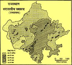
Rajasthan – geographical expansion राजस्थान – भौगोलिक स्थिति एंव विस्तार
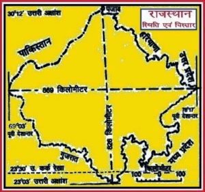
Rajasthan in western part of India, from 23 degrees north latitude 30 degrees 12 to 3 and 6 to 9 between latitude 30 degrees east longitude and 78 ° 17 east longitude, is located between the western border with Pakistan. State of Punjab, east Uttar Pradesh, Haryana in the north-east, south-east and south-west state of Gujarat, Madhya Pradesh, is located. 9 state space of about 3,42,239 square kilometersGeographically the rivers Ganga and Yamuna rivers in the plain of former Rajasthan , Gujarat in the fertile plains of the south – west , south and north in the Malwa Plateau AND northeast Satlg diameter is surrounded by rivers and ground . It extends from east to west and north to south extension of 86 826 km and 9 km . Tropic of Cancer is the southern tip touches .
राजस्थान भारत के पश्चिमी भाग में 23 डिग्री उत्तरी अक्षांश से लेकर 30 डिग्री12 उत्तरी अक्षांश के मध्य तथा 6 से 9 डिग्री 30 पूर्वी देशांतर से 78 डिग्री 17 पूर्वी देशांतर के मध्य स्थित है और इसकी पश्चिमी सीमा पाकिस्तान से लगी है। राज्य के उत्तर में पंजाब, पूर्व में उत्तर प्रदेश, उत्तर-पूर्व में हरियाणा, दक्षिण-पूर्व में मध्य प्रदेश और दक्षिण पश्चिम में गुजरात राज्य स्थित है। राज्य का क्षेत्रफल लगभग 3,42,239 वर्ग किलोमीटर है। भौगोलिक दृष्टि से राजस्थान के पूर्व में गंगा-यमुना नदियों के मैदान, दक्षिण-पश्चिम में गुजरात के उपजाऊ मैदान, दक्षिण में मालवा का पठार तथा उत्तर एंव उत्तर-पूर्व में सतलग व्यास नदियों के मैदान द्वारा घिरा है। इसका पूर्व से पश्चिम का विस्तार 86 9 किलोमीटर और उत्तर से दक्षिण का विस्तार 826 किलोमीटर है। कर्क रेखा इसके दक्षिणी सिरे को छूती हुई जाती है।
Rajasthan is the largest state of India is not only, but also in many countries of the world such as Austria, Great Britain, Italy, Narven, Poland, Ecuador, Malaysia, Vietnam, New Zealand, etc. are larger in terms of area. Its shape is like a lozenge Cturbj. Approximately 1/10 portion of the total area of India in Rajasthan is 10.74 percent. Its range is 20 kilometers in length from 5 to 9 touch the international border with Pakistan in 1070 kilometers.This side of the international border in Rajasthan, Ganganagar, Bikaner, Jaisalmer and Barmer districts. Rajasthan border from Ferozepur district in the north, north-east of Hisar, Sirsa, Mahendergarh and Gurgaon, the former Mathura and Agra in Uttar Pradesh, Madhya Pradesh, in the south-east Morena, Shivpuri, Guna, Rajgarh , Mandsaur and Ratlam, Vadodara in Gujarat in the south-west, Sabarkantha and touches of Bnaskanta
राजस्थान न केवल भारत का सबसे बड़ा राज्य है, बल्कि यह विश्व के अनेक देशों जैसे आस्ट्रिया, ग्रेट ब्रिटेन, इटली, नार्वें, पोलैंड, इक्वेडोर, मलेशिया, वियतनाम, न्यूजीलैंड इत्यादि से क्षेत्रफल की दृष्टि में बड़ा है। इसका आकार एक विषमकोण चतुर्भज जैसा है। भारत के कुल क्षेत्रफल का लगभग 1/10 भाग अर्थात 10.74 प्रतिशत राजस्थान में आता है। इसकी सीमा की लंबाई 826 किलोमीटर है जिसमें से पाकिस्तान को स्पर्श करने वाली अंतराष्ट्रीय सीमा 1070 किलोमीटर है। इस अंतराष्ट्रीय सीमा के इस पार राजस्थान के श्रीगंगानगर, बीकानेर, जैसलमेर और बाड़मेर जिले स्थित हैं। उत्तर में राजस्थान की सीमा पंजाब के फिरोजपुर जिले से, उत्तर-पूर्व में हरियाणा के हिसार, सिरसा, महेन्द्रगढ़ और गुड़गाव से, पूर्व में उत्तर-प्रदेश के मथुरा व आगरा से, दक्षिण-पूर्व में मध्यप्रदेश के मुरैना, शिवपुरी, गुना, राजगढ़, मंदसौर और रतलाम से, दक्षिण-पश्चिम में गुजरात के पंचमहल, साबरकांठा व बनासकंठा से स्पर्श करती है।
more part upload soon
Buy online Rajasthan gk book Railway JE CBT REET PAtwari Book SSC CGL Clerk GD Book Buy online Rajasthan gk book Railway JE CBT REET PAtwari Book SSC CGL Clerk GD Book 0
0 0
0
 0
0