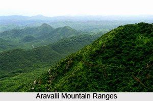
Aravalli mountain range and region अरावली श्रेणी और पहाड़ प्रदेश
Rajasthan Geography, Rajasthan GK 0 Comments
Aravalli mountain range and region अरावली श्रेणी और पहाड़ प्रदेश
The state of Rajasthan is the distinctive mountain range , . It is one of the world’s oldest mountain ranges . Starting from the south – west, north – east of Sirohi Khetri series so far and further north Delhi spans as short chains .
यह प्रदेश राजस्थान की मुख्य एंव विशिष्ट पर्वत श्रेणी है। यह विश्व की प्राचीनतम् पर्वत श्रृंखलाओं में से एक है। यह दक्षिण-पश्चिम में सिरोही से प्रारंभ होकर उत्तर-पूर्व में खेतड़ी तक तो श्रृंखलाबद्ध है और आगे उत्तर में छोटी-छोटी श्रृंखलाओं के रुप में दिल्ली तक विस्तृत है।
प्रमुख चोटियां हैं-
short trick : गुरु से जरा आसा रखो
(1) गुरुशिखर (1722 मीटर)
(2) सेर- 1597 मीटर
(3) अचलगढ़- 1380 मीटर
(4) देलवाड़ा- 1442 मीटर
(5) आबू- 1295 मीटर
(6)रघुनाथगढ़ 1055 मीटर
(7) ऋषिकेश- 1017 मीटर
(8)खौ 950 मीटर
Garbhik history in terms of geo-Dharwad Aravalli Range is concerned with the end of time. This series Smpray: Cambrian era was again raised by the end of the mountain range and Vidhyyn period came into existence. First in the series Mesajoik era Smpray: Punrotthit occurred prior to the beginning of time, and Trsri. The southward expansion is currently under the sea. Trsri period after the aggregation of the Deccan TrapThe state Failaits , elegant , Nice and is dominated by granite rocks . The state is the height of 1225 meters
भू–गार्भिक इतिहास की दृष्टि से अरावली श्रृंखला धारवाड़ समय के समाप्त होने के साथ से संबधित है। यह श्रृंखला समप्राय: थी और केम्ब्रियन युग में पुन: उठी और विध्ययन काल के अंत तक यह पर्वत श्रृंखला अपने अस्तित्व में आयी। सर्वप्रथम यह श्रृंखला मेसाजोइक युग में समप्राय: हुई और टरशरी काल के प्रारंभ में पूर्व पुनरोत्थित हुई। इसका दक्षिण की ओर विस्तार जो इस समय समुद्र के नीचे है। टरशरी काल में दक्कन ट्रेप के एकत्रीकरण के पश्चात् हुआ। इस प्रदेश में फाइलाईट्स, शिष्ट, नीस और ग्रेनाइट चट्टानों की प्रधानता है। इस प्रदेश की ऊँचाई 1225 मीटर है। :
The mountain can be divided into four parts order इस पर्वत क्रम को चार भागों में बाँटा जा सकता है
(1) North – eastern mountainous range उत्तरी–पूर्वी पहाड़ी श्रेणी,
(2) Middle Aravalli Range – which again can be divided into two parts मध्य अरावली श्रेणी – जिसे पुन: दो भागों में बाँटा जा सकता है:–
( A) Shekhawati low hills and ( b) Mervadh Phadi (अ) शेखावटी निम्न पहाड़ियाँ व (ब) मेरवाड़ पहाड़ियाँ
(3) Mewar hills and plateau Bhorat मेवाड़ पहाड़ियाँ और भोराट पठार
(4) Abu Prwatkram. आबू पर्वतक्रम।
(1) North-eastern hill country – The north-western parts of the district in Jaipur and Alwar in most parts of the district wide. Rocky and precipitous ridge of hills in this part includes several parallel. Failait This part of the Aravalli range and is made from quartz. The state of Delhi is built from limestone rocks at runtime.
(1) उत्तरी–पूर्वी पहाड़ी प्रदेश – यह जयपुर जिले के उत्तरी–पश्चिमी भागों में तथा अलवर जिले के अधिकांश भागों में विस्तृत है। इस भाग में चट्टानी और प्रपाती पहाड़ियों के कई समानान्तर कटक सम्मिलित हैं। अरावली का यह भाग श्रृंखला–फाइलाईट और क्वार्टज से निर्मित है। इस प्रदेश की दिल्ली क्रम की अन्य चट्टानें चूने के पत्थर से निर्मित है।
( 2 ) Middle Aravalli – Ajmer , Jaipur and Tonk districts located in the south – west . The intermediate part of the Aravali order . Under this, scattered in the West Ridge , Alwar hills, including Karoly high ground and Banas field . It ( a) Shekhawati low hill country and ( b) can be divided into Mervadh hill country .
(2) मध्य अरावली पर्वत श्रेणी – यह अजमेर, जयपुर तथा टोंक जिलों के दक्षिण–पश्चिम में स्थित है। यह अरावली पर्वत क्रम का मध्यवर्ती भाग है। इसके अन्तर्गत पश्चिम में बिखरे कटक, अलवर पहाड़ियाँ, करोली उच्च भूमि और बनास मैदान सम्मिलित है। इसे (अ) शेखावटी निम्न पहाड़ी प्रदेश और (ब) मेरवाड़ पहाड़ी प्रदेश में विभाजित किया जा सकता है।
( A) Shekhawati Sambhar lake in the hill country , starting with the long range goes Sihna in Jhunjhunu district . Besides a number of smaller hills which Dhat old , Nahar Garh, transversal , Dungar , Rahodi , Tora Wati etc . Average height is 400 meters to the hills .
(अ) शेखावटी निम्न पहाड़ी प्रदेश में सांभर झील से प्रारंभ होने वाली सबसे लंबी श्रेणी झुंझुनू जिले में सिहना तक जाती है। इनके अतिरिक्त अनेक छोटी–छोटी पहाड़ियां हैं जिनमें पुराना धाट, नाहर गढ़, आड़ा, डूंगर, राहोड़ी, तोरा वाटी आदि हैं। इन पहाड़ियों की औसत ऊँचाई 400 मीटर है।
( B) Mervadh high plateau of the hill country of Marwar, Mewar ground isolated from the mountain range that appears near Ajmer . Taragarh in the hills ( 870 m ) near Ajmer is the key . Snake Mountain to the west . The entire region has an average elevation of 550 meters .
(ब) मेरवाड़ पहाड़ी प्रदेश मारवाड़ के मैदान को मेवाड़ के उच्च पठार से पृथक करने वाली पर्वत श्रेणी है जो अजमेर के निकट प्रकट होती है। इन पहाड़ियों में तारागढ़ (870 मीटर) प्रमुख है जो अजमेर के निकट है। इसके पश्चिम में नाग पहाड़ है। संपूर्ण प्रदेश की औसत ऊँचाई 550 मीटर है।
(3 ) Burat Mewar hills and plateau – the Mewar hills and the eastern plateau Burat Sirohi , Udaipur, Udaipur, and almost all of the formerly narrow strip excluding detailed dungarpur districts . To the east of this part or the Aravalli Hasrt Brsotth as 1530 meters . The general structure of folding in the territory from the east to the south – west side Smnti Vlnon dip is visible upon perpendicular
(3) मेवाड़ पहाड़ियाँ और भौराट पठार – मेवाड़ पहाड़ियाँ और भौराट पठार वह हैं जो पूर्वी सिरोही, उदयपुर के पूर्व में संकीर्ण पट्टी को छोड़कर लगभग संपूर्ण उदयपुर और डूंगरपूर जिलों में विस्तृत है। इस भाग के पूर्व में अरावली हास्र्ट अथवा भ्रशोत्थ के रुप में 1530 मीटर तक है। इस भू–भाग में वलन की सामान्य संरचना उत्तर–पूर्व से दक्षिण–पश्चिम की ओर समनति वलनों के नति लम्ब के सहारे दृष्टिगोचर होती है।
(4) Mount Abu order – it is located in the south west of the Aravalli range. This cluster of hills as detailed in Sirohi district. Its key feature near Abu often isolated as the hill. Here are the major peak. To the west of Abu Abu, Sirohi classes. It is very low in the west than in Abu categories, these categories as class joins dispersed hills and reach the Palanpur-intensive approach has become.Mixed deciduous and evergreen subtropical vegetation in the mountain region is devoid. Generally Dukdha, banyan, fig, mango, Jamun, acacia trees and well etc. are found.
(4) आबू पर्वत क्रम – यह अरावली श्रृंखला के दक्षिण–पश्चिम में स्थित है। यह सिरोही जिले में पहाड़ियों के गुच्छे के रुप में विस्तृत है। इसकी प्रमुख विशेषता आबू के निकट प्राय: पृथक पहाड़ी के रुप में है। यहां के प्रमुख शिखर हैं। आबू के पश्चिम में आबू, सिरोही श्रेणियां है। यह आबू श्रेणियों की अपेक्षा बहुत नीची है और पश्चिम में जाने पर ये श्रेणियां छितरी पहाड़ियों के वर्ग के रुप में मिलती है और पालनपुर पहुँचते–पहुँचते सधन हो जाते है। इस पर्वत प्रदेश में मिश्रित पर्णपाती और उपोष्ण सदाबहार वनस्पति विहीन है। समान्यत: धौकड़ा, बरगद, गूलर, आम, जामून, बबूल व खैर आदि के वृक्ष पाए जाते हैं।
(4)पूर्वी मैदान (This part upload soon)
more click Here: Natural Part Of Rajasthan राजस्थान के प्राकृतिक भाग
Buy online Rajasthan gk book Railway JE CBT REET PAtwari Book SSC CGL Clerk GD Book Buy online Rajasthan gk book Railway JE CBT REET PAtwari Book SSC CGL Clerk GD Book
 0
0 0
0
 0
0